Earth Sciences - Geology
155 items found

Karrer, F.
Geologie der Kaiser Franz Josefs Hochquellen-Wasserleitung. Eine Studie in den Tertiär-Bildungen am Westrande des alpinen Theiles der Niederung von Wien.
Wien, Hölder, 1877. Large 4to (33.5 x 25.5 cm). xiii, 420 pp.; 96 text engravings, 20 folded profiles, maps and lithographed plates, mostly coloured and several very large (size up to 32 x 100 cm), seven folded charts and tables. Later half cloth with paper label on the spine.
Read more
Oeynhausen, C. von and H. von Dechen and H. von La Roche
Geognostische Umrisse der Rheinländer zwischen Basel und Mainz mit besonderer Rücksicht auf das Vorkommen des Steinsalzes, nach Beobachtungen entworfen auf einer Reise im Jahre 1823 gesammelt.
Essen, G. Bädeker, 1825. Two volumes in one. 8vo (19.8 x 12.0 cm). 782 pp.; one folding lithographed plate with several geological profiles. Contemporary half cloth over marbled boards. Paper label with the title in an old hand on the spine. Original endpapers.
Read more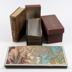
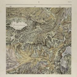
[Geological map]
Geognostische Karte von Württemberg [AND] Begleitworte zur geognostischen Specialkarte von Württemberg.
Stuttgart, Das Königliches Statistisch-topographisches Bureau, Kohlhammer, Kleeblatt, 1863-1892. With 54 chromolithographed folded geological maps, all mounted on linen, numbered 1-48, 50-55, in two original, uniform burgundy boxes with gilt title on the lid. [AND] the "Begleitworte" 34 parts in one. Large 8vo (25.7 x 19.5 cm). Stuttgart, Königlich Statistischen Landesambt, (1865-1892). ca. 1,000 pp., and five hand-coloured wood-engraved or lithographed maps or geological profiles, and four wood-engraved plates. Contemporary half cloth over marbled boards. Spine with gilt title, ornaments, and the Württemberg coat-of-arms; patterned endpapers, and marbled edges.
Read more
Lippi, C.
Fu il fuoco, o l'acqua che sotterro Pompei ed Ercolano? Scoperta geologico-istorica, fatta dall'autore il di 14 e 26 Ottobre 1810, e da lui scritta nelle lingue latina, inglese, francese, italiana, tedesca, e spagnuola in due lettere. Seguite dalle scritture pro et contra, presentate all' Accademia di scienze di Napoli, per di lei ordine; e dalle decisioni di questa Società, relative al' argomento. Prima edizione Italiana.
Napoli, Domenico Sangiacomo, 1816. 8vo (18.9 x 11.4 cm). [iv], 384 pp.; one folded plate. Contemporary half calf over marbled boards. Rich gilt spine. Edges yellow.
Read more
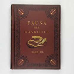
Fritsch, A.
Fauna der Gaskohle und der Kalksteine der Permformation Böhmens. Band I-IV. [Complete].
Prag, Selbstverlag and F. Řivnáč, 1879-1899 [1901?]. Four volumes in four. Folio (34.0 x 25.5 cm). 459 pp., lavishly illustrated with 167 mostly chromolithographed plates (several double-sized or larger, folded), and over 400 text engravings, of which some plate-sized. Volume I (1883): 182 pp., 48 plates (some larger, folded, a few plain), 160 text engravings; volume II (1889): 114 pp., 44 plates (several larger, folded; numbered 49-90, 80b, 81b), 79 text figures (numbered 117-188); vol. III (1895): 132 pp., 42 plates [several (much) larger; numbered 91-132], 122 text engravings (numbered 189-310); vol. IV (1901): 101 pp., full colour frontispiece, of a landscape with "Miriopoden"; 33 plates (numbered 133-165), 64 text engravings (numbered 311-394, and including phototypes of fossil animals and tracks, freshwater bivalves, and, e.g. the author at work). Original uniform brown cloth sumptuously embossed with black floral borders, and gilt vignettes depicting Permian amphibians, reptiles and fish. Marbled edges.
Read more
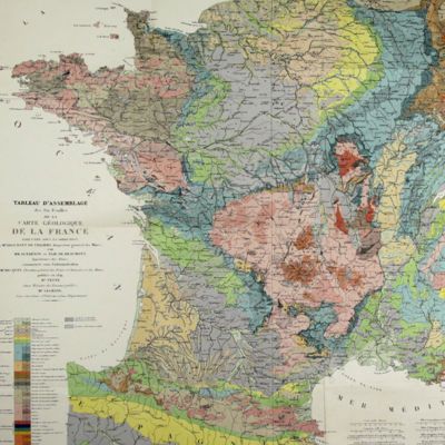
Dufrenoy, [O. P. A.] and [J. B. A. L. L.] Élie de Beaumont
Explication de la carte géologique de la France. Volumes I-IV (text and atlas), and two maps. [Complete].
Paris, Imprimerie Royale, Imprimerie Nationale, 1841-1879. Four volumes in seven, and a large map in six folded sheets, each ca. 70 x 205 cm (including borders) with linen covers. Large 4to (four text volumes; ca. 27.5 x 21.0 cm); folio (two atlas volumes, 26.8 x 35.7 cm). Tome premier: Paris, Imprimerie Royale, 1841. Large 4to. xxii, 825 pp., 71 text engravings (mainly profiles); Tome deuxième: Paris, Imprimerie Nationale, 1848. Large 4to. xii, 813 pp., 105 text engravings (mainly views and profiles), one large, folded chromolithographed geological map (finished by hand) of France (printed surface: 57 x 54 cm, and consisting of 15 smaller sections, mounted on linen and folded) bound in the rear; Tome troisième. Première partie (by Dufrénoy): Paris, Imprimerie Nationale, 1873. Large 4to. viii, 231 pp., 18 text engravings (mainly profiles). Printed wrappers. Tome quatrième. Seconde partie. Végétaux fossiles du terrain houiller (by Zeiller): Paris, Imprimerie Nationale, 1879. Large 4to. 185 pp. Printed wrappers; Tome quatrième. Atlas (in two volumes). Première partie. Fossiles principaux des terrains (by É. Bayle). Seconde partie. Végétaux fossiles du terrain houiller (by Zeiller): Paris, Imprimerie Nationale, 1878. Folio. Title page, half title to first part. 86 lithographed plates with explanatory text leaves, numbered I-LXXXVI; 90 lithographed plates with explanatory text leaves, numbered LXXXVII-CLXXVI (the last 16 on plants), for a total of 176 plates. Volumes I, II, and IV plate volumes in near uniform contemporary dark-green pebbled morocco over marbled boards. Spines with five gilt-stippled bands, and gilt title. Marbled endpapers. The text volumes with top edge gilt, atlases with marbled top edges. Text volumes III and IV in original printed wrappers. The large chromolithographed map in six sheets (approximately 218 x 223 cm) is contained in a contemporary, book-like crimson box with gilt-lettered spine, with raised bands and patterned paper sides.
Read more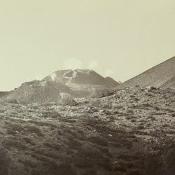
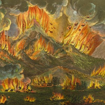
Silvestri, O.
Etna. Eruzione e terremoti del Maggio-Giugno 1879. Fotografie fatte per incarico del R. Governo Italiano sotto la direzione del Prof. Orazio Silvestri.
[Catania], A. T. Tagliarini, "1879" [1880]. Oblong folio, with 30 (of 33 or 34?) original albumen prints of slightly variable size, on average 17.5 x 32.0 cm (plates 1-22), or four times 19 x 24 cm (plates 23-24), all mounted on 24 (of 25?) very large printed boards, each 48.5 x 56.8 cm and with a gilt frame of 29.2 x 39.1 cm (plates 1-22), or four times 20.4 x 25.8 cm (plates 23-24) with printed captions mounted, and printed captions on the boards. In clamshell box of navy pebbled cloth over marbled boards (58.3 x 51.4 x 3.7 cm) with original printed labels on the front board recto and verso.
Read more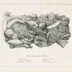
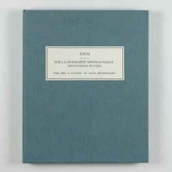
Cuvier, G. and A. [T.] Brongniart
Essai sur la géographie minéralogique des environs de Paris. Proof copy of the introductions, with corrections by Brogniart.
Paris, Institut Impériale de France, [1809 or 1810]. 4to (25.0 x 20.0 cm). 33 pp. Not bound. In a 20th century blue hardcover paper drop-box (26.8 x 22.0 cm) with printed label on the top board.
Read more
Devèze de Chabrol, J. S. and J. B. Bouillet
Essai géologique et minéralogique sur les environs d'Issoire, département du Puy-de-Dôme, et principalement sur la Montagne de Boulade.
Clermont-Ferrand, Thibaud-Landriot, 1827. Folio (41.0 x 26.2 cm). xii, 104 pp.;hand-coloured lithographed geological map and hand-coloured profile, and 30 lithographed plates depicting vertebrates and several tables, including one very large, folded in the text. Contemporary half morocco over marbled boards. Spine with gilt lines and title. Marbled endpapers; speckled edges.
Read more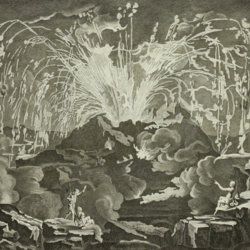
Diderot, D. and J. d'Alembert (eds.)
Encyclopédie ou dictionnaire raisonné des sciences, des arts et des métiers, par une société de gens de lettres mis en ordre par Mons. Diderot. Histoire naturelle. Règne mineral.
Paris, Diderot et d'Alembert, 1768. Folio (43.2 x 27.2 cm). 4 pp., 130 plates (partly folded). Disbound.
Read more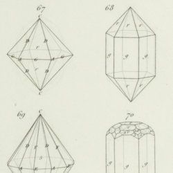
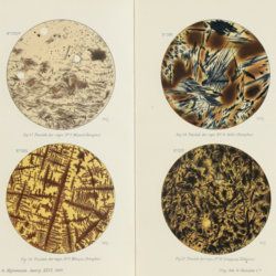
Rose, G.
Eléments de cristallographie.
Paris, Hachette et Firmin Didot, 1834. 8vo (19.9 x 12.7 cm). 270 pp.; title page (to IIe partie - planches), 12 pp.; 10 double-sized engraved plates with 121 figures, numbered 1-108 (plates I-IX), and 1-13 (plate X). Contemporary half calf over marbled boards. Spine with gilt lines and title. Marbled endpapers.
Read more
[Bertrand, B. N.]
Elemens d'oryctologie ou distribution méthodique des fossiles.
Neuchatel, Société Typographique, 1773. 8vo (18.8 x 11.5 cm). xxxix, 137, xxii pp.; 16 double, folded tables. Contemporary full calf. Spine with four raised bands. Rich gilt floral compartments, red morocco label with gilt title. Edges red.
Read more
Rothpletz, A.
Ein geologischer Querschnitt durch die Ost-Alpen nebst Anhang über die sog. Glarner Doppelfalte.
Stuttgart, E. Schweizerbart (E. Koch), 1894. 8vo (22.4 x 15.4 cm). iv, 208 pp.; two full colour folded profiles of which one measuring 22.5 x 352.0 cm (!), 115 text illustrations. Contemporary half cloth over marbled boards. Gilt lines and two red morocco labels with gilt title on the spine. Edges speckled.
Read more
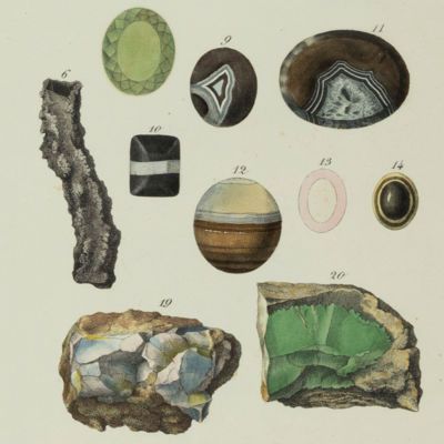
Nicols, T.
Edelgestein-Büchlein, oder Beschreibung der Edelgesteine. Derer Gestalt, Kräffte und Tugenden, Eigenschafften, Preiß und Werth. Samt beygefügten Warnungen für Betrug an alle diejenigen, so mit Edel-Gesteinen handeln und umbgehen. Durch Thomas Nicols Professoren der Hohen-Schule zu Cambridge. Goldschmiede und Liebhabern der Edelgersteine zu sonderbahren Gefallen auffbegehren auß dem Englischen in Teutsch übersetzet und herausgegeben von Johann Langen.
Hamburg, Johann Nauman und Georg Wolff, 1675. Small 8vo. (15.7 x 9.3 cm). [xiv], 249, [vii] pp. Contemporary style half morocco over boards. Spine with blind-tooled title. Red edges.
Read more
Fuchs, W.
Die Venetianer Alpen. Ein Beitrag zur Kenntniss der Hochgebirgte, met einen geognostischen Karte und Gebirgteprofilen in achtzehn Tafeln.
Solothurn, Jent & Gassmann, 1844. Oblong folio (29.8 x 35.5 cm), [4], 60 pp.; 18 mostly hand-coloured engraved maps and plates. Text pages bordered with putti and goddesses. 19th century iridescent blue blind cloth.
Read more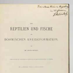
Fritsch, A. [J.]
Die Reptilien und Fische der böhmischen Kreideformation.
Prag, Verlag des Verfassers (Fr. Řivnáč), 1878. Large 4to (33.5 x 25.1 cm). [ii], 44, [ii] pp.; 66 text engravings; ten lithographed plates of which nine tinted, and two larger, folded. Original blind quarter linen over printed boards.
Read more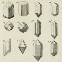
Faber, F. C. Von
Die Kraterpflanzen Javas in physiologisch-ökologischer Beziehung.
Buitenzorg, 's Lands Plantentuin - Botanischer Garten, 1927. Large 8vo (24.1 x 17.0 cm). iv, 119 pp.; 12 text illustrations, 18 fine photographic plates. A unique pattered batik-cloth binding with gilt title on the spine and front board. Original printed front wrapper bound in.
Read more
Ettingshausen, C., von
Die Fossile Flora des Tertiär-Beckens von Bilin. I Theil. (Enthaltend die Thallophyten, Kryptogamischen Gefässpflanzen; Monokotyledonen, Coniferen, Julifloren und Oleraceen).
Wien, Kaiserlichen Akademie der Wissenschaften, 1867. 4to (29.6 x 23.1 cm). 95 pp.; 30 tinted lithographed plates. Later boards, printed label mounted on front board.
Read more
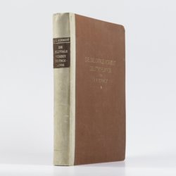
Schmidt, R. R.
Die diluviale Vorzeit Deutschlands.
Stuttgart, E. Schweizerbart (Nägele und Dr. Sproesser), 1912. Very large 4to (35.5 x 30.0 cm). xiii, 283 pp.; 47 engraved or heliogravure plates with explanatory text leaves, loose in rear pocket. Original quarter vellum over cloth boards. Gilt title on front board; gilt-lettered morocco label on the spine.
Read more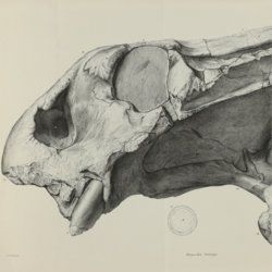
Owen, R.
Descriptive and illustrated catalogue of the fossil Reptilia of South Africa in the collection of the British Museum.
London, The Trustees of the British Museum, 1876. Folio (32.5 x 25.2 cm). xii, 88 pp.; 70 fine lithographed plates, several larger, and folded. Original green pebbled and blind-tooled cloth. Gilt title on the spine.
Read more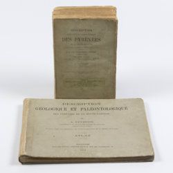
Leymerie, A. [F. G. A.]
Description géologique et paléontologique des Pyrenées de la Haute-Garonne accompagnée d'une carte topographique et géologique à l'echelle 1:200.000 et d'un Atlas...
Toulouse, Privat, 1878, 1881. In two volumes. Text (1881) 8vo (24.0 x 16.0 cm). Atlas (1878) oblong 4to (23.5 x 31.5 cm). 1,027 pp.; 51 lithographed plates of which 11 tinted or coloured (and of which 30 are on fossils), including a large folded transection of the Pyrenees, Haute Garonne, and the large coloured geological map (with 20 colours) mounted on linen. Original printed wrappers (text) and boards (atlas).
Read more
Passy, A. [F.]
Description géologique du département de la Seine-Inférieure. [Text and Atlas].
Rouen, Nicétas Periaux, 1832. Two parts [text and atlas] in one. 4to (26.7 x 21.3 cm). 402 pp. [xvi, 371; 15]; 20 engraved plates (several double-sized), of which 15 in original hand-colouring. Contemporary quarter morocco over marbled boards; spine with gilt title. Marbled endpapers.
Read more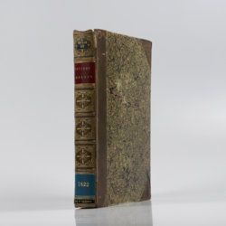
Cuvier, G. [L. C. F. D.] and A. Brongniart
Description géologique des environs de Paris, par MM. G. Cuvier et Alex. Brongniart. Nouvelle édition, dans laquelle on a inséré la descrition d'un grand nombre de lieux de l'Allemagne, de la Suisse, de l'Italie, etc., qui présentent des terrains analogues a ceux du Bassin de Paris. Avec 2 cartes et 16 planches représentant les coupes de ces terrains et beaucoup des coquilles fossiles qu'ils renferment, et une table alphabétique de tous les lieux décrits ou seulement cités.
Paris, G. Dufour et E. d'Ocagne, 1822. 4to (29.3 x 22.2 cm). ix, 428 pp.; one brightly hand-coloured geological map of the surroundings of Paris, and 17 lithographed plates, including one hand-coloured geological map of the basins of London and Paris. Contemporary half calf over marbled boards. Spine with five raised, gilt-ornamented bands; compartments rich gilt, and with two morocco labels (red and blue) with gilt title.
Read more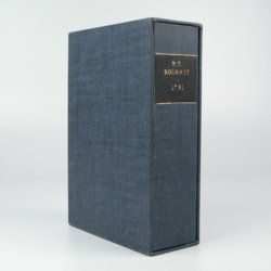
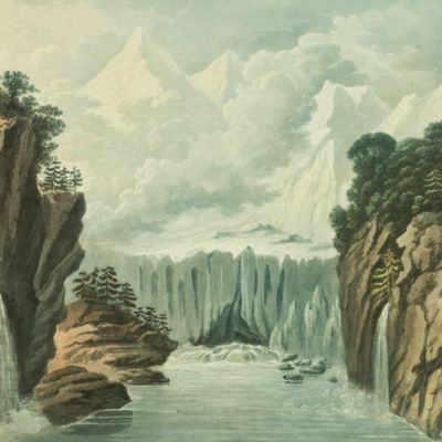
Bourrit, M. T.
Description des Alpes, Pennines et Rhetiennes; dédiée a.s.m. très-chrétienne Louis XVI, roi de France et de Navarre. Tome premier - second. [Complete].
Genève, J. P. Bonnant, 1781. In two volumes. 8vo (21.5 x 13.8 cm). xix, 247 pp.; [ii], 285 pp.; eight engraved plates, mainly of glaciers, and one folded engraved map of the Alps, several wood engraved vignettes in the text. Original uniform blind publishers' wrappers. Spines renewed with later printed labels. Contained in a later blue cloth slipcase (23.2 x 15.8 x 6.9 cm) with black morocco label with gilt title.
Read more
Gmelin, J. F. [Linnaeus]
Des Ritters Carl von Linne Königl. Schwedischen Leibarzes & c. vollständiges Natursystem des Mineralreichs nach den zwölften lateinischen Ausgabe in einer freyen und vermehrten Uebersetzung. Erster - Vierter Theil. [Complete].
Nürnberg, Gabriel Nicolaus Raspe, 1777-1779. Four volumes in four. 8vo (19.3 x 12.0 cm). Title pages, 2274 pp. (I [1777]: [ii], 652; II [1778]: [xiv], 496, [viii]; III [1778]: [xiv], 486; IV [1779]: lxiv, 528, [x]); 57 finely engraved plates [1-5; 1-9; 1-9, 5B, 5C, 6B, 7B; 10-36, 16b, 20b, 21b]. Contemporary boards with two, burgundy and near-uniform brownish morocco labels with gilt or black, embossed title and volume number. Edges red. One volume with a contemporary binding in half-vellum-over-speckled-boards beneath.
Read more
Wahlenberg, G.
De vegetatione et climate in Helvetia Septentrionali inter flumina Rhenum et Arolam observatis et cum summi septentrionis comparatis tentamen.
Turici Helvetorum (Zürich), Fuessli, 1813. 8vo (20.5 x 12.1 cm). xcviii, 200 pp.; one folding table, three folded engraved plates. Contemporary half calf over marbled boards. Spine with gilt ornaments at head and food; red morocco label with gilt title. All edges red.
Read more
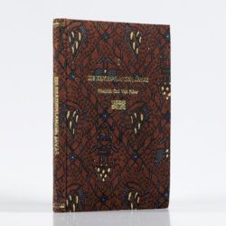
Kaempfer, E.
De beschryving van Japan, behelsende een verhaal van den ouden en tegenwoordigen staat en regeering van dat Ryk.
The Hague, P. Gosse and J. Neaulme; Amsterdam, Balthasar Lakeman, 1729. Folio (37.5 x 25.0 cm). 500 pp. Half-title, title page explanation, frontispiece (engraved title) by I. C. Philips, letterpress title in red and black; 48 double-sized maps and plates (I-XVII, XXX-XLV, XXIV*, A-BXXVIII, A-BXXIX). Contemporary full mottled calf; spine with six raised bands; compartments rich gilt with fine, elaborate floral ornaments, and red morocco label with gilt title; boards with double gilt roll stamped border, gilt floral corner pieces and central vignettes. Mottled edges.
Read more
Adriani, N. and A. C. Kruyt
De Bare'e sprekende Toradjas van Midden-Celebes. [Complete, in four volumes].
Batavia, Landsdrukkerij, 1912-1914. In four volumes. Text in three octavo volumes (26.5 x 18.0 cm) [AND] atlas in folio portfolio (37.0 x 26.5 cm). 1,636 pp.; 58 photographs on 26 sheets, 13 coloured plates of which seven partly in full colour, and four coloured folding maps (two showing adjacent regions). Original uniform quarter cloth over printed boards.
Read more
Tollmann, A.
Das Neogen am Südwestrand des Leithagebirges zwischen Eisenstadt und Hornstein. Dissertation zur Erlangung des Doktorgrades an der Philosophischen Fakultät der Universität Wien.
Wien, [not published], 1953. Small folio (29.8 x 21.0 cm). 226 pp.; 28 text figures (tipped in), three large folded maps (one hand-coloured), five folded tables and graphs. Black half cloth. Hand-written label on the spine.
Read more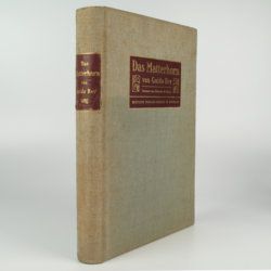
Rey, G.
Das Matterhorn. Vorwort von E. de Amicis with geologische Erläuterungen by V. Novarese.
Stuttgart and Leipzig, Deutsche Verlags-Anstalt, 1905. 4to (29.2 x 21.0 cm). xi, 258 pp.; 35 plates of which 14 are nicely tinted photographic plates after water-colours, mounted on black paper, all by Edoardo Rubino and 11 photographs (most by Vittorio Sella and a few by G. Rey) and ten photographic plates from drawings also by Edoardo Rubino. Furthermore there are 13 images of drawings in the text also by Edoardo Rubino [complete]. Original cloth with bevelled edges, gilt mounted title piece on front board and gilt-lettered spine label. Mottled olive endpapers. Top edge gilt.
Read more
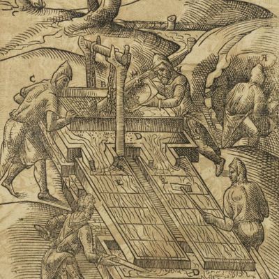
[Lehmann, J. G.]
Darstellung einer neuen Theorie der Bezeichnung der schiefen Flächen im Grundriss oder der Situationszeichnung der Berge.
Leipzig, Johann Benjamin Georg Fleischer, 1799. 8vo (19.6 x 12.0 cm). xx, 172 pp.; four large, folded, engraved plates. Contemporary full tree calf. Spine with morocco label with gilt ornamental lines and title. Edges pale yellow.
Read more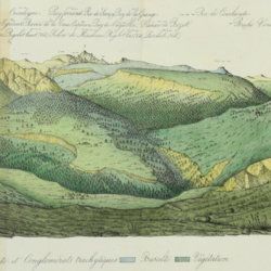
Lecoq, H. and J. B. Bouillet
Coup d'oeil sur la structure géologique et minéralogique du groupe des Monts Dores, accompagné de la description et des échantillons des substances minérales qui le composent.
Paris, Levrault and Clermont-Ferrand, Bouillet, Thibaud-Landriot, 1830. 8vo (20.0 x 13.1 cm). 48 pp.; five handcoloured lithographed plates (two much larger, folded) of geological views and profiles of the volcanological region of Puy-de-Dôme. Later red quarter calf over marbled boards. Gilt title on the spine. Marbled endpapers. Speckled edges.
Read more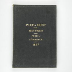
Mille, M. et al.
Contrôle des Chemins de Fer. Ligne de Paris à Brest. Réseau d'Orléans. Profil géologique suivant le tracé du chemin de fer dressé sur les indications de M.M. Triger et Delesse. Notice par M. Mille ingénieur en Chef des Ponts et Chaussées 1867.
Paris, Jules Bonaventure, 1866-1867. In four parts. 4to. Title-page, 9 pp. (text volume); one folded, chromolithographed profile (31.0 x 99.8 cm), titled: Coupe des huillères de Chalonnes d'après les travaux des ingénieurs de la mine; one very long folded profile (31 x 957 cm, including title and legend) titled: Section de Paris à Angers par Vendôme et Tours; a second very long folded chromolithographed profile (31 x 1147 [!] cm), title: Section de Angers à Brest par Nantes et Chateaulin. All four contained in a blind stamped cloth portfolio with gilt title on the spine and top board.
Read more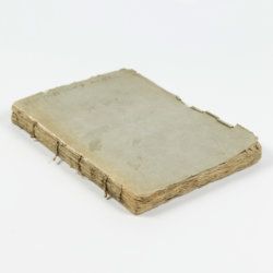
Martini, [F. H. W.] (ed.)
Beschäftigungen der Berliner Gesellschaft Naturforschender Freunde. Zweeter Band.
Berlin, Joachim Pauli, 1776. 8vo (19.2 x 11.2 cm). Title page with finely engraved vignette; xl, 607 pp.; 14 folded, engraved plates of which ten in original hand-colouring (plates numbered I-XIII, IXA). Original speckled paper covered boards with paper label on the spine. Speckled edges.
Read more
Nicols, T.
Beschreibung der Steine sowohl Edel als Gemeine, darinnen derer Gestalt, Kräffte, Tugenden, Medicin-Eigenschaften, Preiss und Werth auf das deutlichste gezeignet wird Samt beygefesten Warnungen sich für derer Verfälschung wohl zu hüten wegen seiner fürtrefflichkeit aus dem Englischen ins Teutsche übersetzt durch Johann Langen.
Culmbach, Nathaneal Lumscher, 1734. Small 8vo (16.4 x 10.3 cm). 16, 274, [xiv] pp.; wood-engraved head and tail pieces. Contemporary half vellum over marbled boards. Speckled edges.
Read more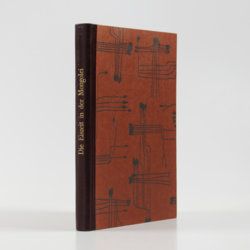
Granö, J. G.
Beiträge zur Kenntnis der Eiszeit in der Nordwestlichen Mongolei und einigen ihrer südsibirischen Grenzgebirge. Geomorphologische Studien aus den Jahren 1905, 1906, 1907 und 1909.
Helsingfors, J. Simelii [for the Geographical Society of Finland], 1910. Large 8vo (24.9 x 16.5 cm). iv, 230 pp.; seven large, folded coloured maps, 19 photographic plates. Later quarter calf over pictorial boards.
Read more