
North Pacific
3 items found
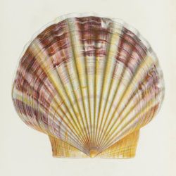
Lischke, C. E.
Japanische Meeres-Conchylien. Ein Beitrag zur Kenntniss der Mollusken Japan's, mit besonderer Rücksicht auf die geographische Verbreitung derselben. I - III. [Complete].
Cassel [Kassel], Theodor Fischer, 1869-1875. Three volumes in one. 4to (28.2 x 21.7 cm). Three title pages; 503 pp. ([ii], 192; [ii], 184; 123]); 37 [14; 14; 9] fine, hand-coloured lithographed plates. Later grained green half calf over marbled boards. Spine with four raised, gilt-ornamented bands and two green morocco labels with gilt title.
Read more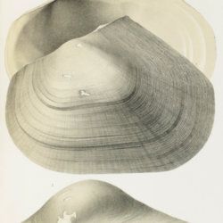
Schrenck, [P.] L. [I.] von
Reisen und Forschungen im Amur-Lande 1854-1856. Volume 2, Heft 3. Mollusken des Amur-Landes und des Nordjapanischen Meeres.
Saint Petersburg, 1859-1867. Folio (33.0 x 23.2 cm). Half-title. 718 pp. [numbered (259)-976]; 17 finely lithographed plates and two large, folding maps [numbered consecutively, XII-XXX]. Navy cloth. Spine with black label with gilt title.
Read more
Tizard, T. H. et al. (eds.) [Thomson, C. W. and J. Murray (general editors)]
Report on the scientific results of the voyage of H.M.S. Challenger during the years 1873-76 under the command of captain George S. Nares, R.N., F.R.S. and the late captain Frank Tourle Thomson, R.N. prepared under the superintendence of the late Sir C. Wyville Thomson, Knt., F.R.S., &c. and now of John Murray. Volumes I - II. Narrative of the Cruise. [The complete narrative].
London, Her Majesty's Stationery Office, 1882-1885. Two volumes in three. 4to (29.2 x 24.6 cm). Volume I (in two parts) (1885): liv, 1111 pp.; two elongate photographic frontispieces; 340 numbered (groups of) woodcuts and many unnumbered, often acting as head- or tailpieces; 75 charts; 35 numbered photographic plates; 15 chromolithographed plates (numbered A-I, K-P), and a very large map (in two parts) of both hemispheres, with the complete itinerary, in a rear pocket in Part I; a second, very long, full-colour map on the salinity of the oceans in Part 2. Volume II (1882): viii, 744, 42, 29 pp.; several text engravings and two plates, of which one in chromolithography, and a tipped-in note on the reason for publishing Volume II ahead of Volume I. Original, uniform, dark-green blind-stamped pebbled cloth. Boards with bevelled edges. Gilt title on the spines. Brown endpapers.
Read more
