
Rocky Mountains
3 items found
Guillemin-Tarayre, E.
[Mission scientifique au Mexique et dans l'Amérique Centrale.] Description des anciennes possessions mexicaines du Nord.
[Paris, Ministre de l'Instruction Publique (Imprimerie Nationale)], 1871. Large 4to (36.9 x 28.1 cm). 216 pp.; 29 text engravings, one coloured engraved map "Carte de la Haute Californie et de la Nevada" (not numbered), one lithographed plate of indigenous people ("p. 15"), 18 lithographed plates and maps, all but two double-sized or larger [numbered I-XVII, one not numbered], for a total of 20 plates and maps [Complete]. All leaves loose, as issued. Original printed wrappers.
Read more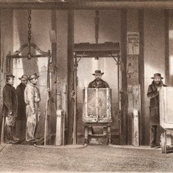
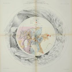
Hague, J. D. and C. King
United States geological exploration of the fortieth parallel. Volume III. Mining industry by James D. Hague. With geological contributions by Clarence King. [AND] Mining Industry atlas. [COMPLETE including the nearly always missing Atlas].
Washington, DC, Government Printing Office, 1870; New York, NY, Julies Bien, [1870]. Large 4to (29.2 x 23.2 cm) and very large, oblong folio (49.0 x 64.2 cm). Lithographed frontispiece, xiii, 646 pp.; 37 plates and maps (text volume); [AND] title page; 14 large maps, of which all but one hand-coloured or colour-printed (atlas volume). Original green cloth with embossed boards and gilt title on the spine (text volume); [AND] original green half roan over green cloth. Front boar with gilt title (atlas volume).
Read more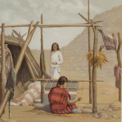
Wheeler, G. M.
Report upon United States Geographical Surveys west of the one hundredth meridian, in charge of Capt. Geo. M. Wheeler. Vol. I. - Geographical report.
Washington, DC, Government Printing Office, 1889. Large, thick 4to (29.3 x 23.5 cm). 780 pp.; 38 fine, tinted lithographed plates (several in chromolithography, tissue-guarded), three (very) large folded maps [listed as plates I-XXXVIII and Maps 1-3]. Publisher's embossed cloth. Spine with gilt vignette and title. Printed errata slip bound in; Wheeler's printed compliments tipped in on the front pastedown.
Read more
