![Spoor- en Tramwegkaart van Java en Madoera. [1909 edition].](https://www.schierenberg.nl/media/cache/product_main/76139/76139_x.jpg)
[Rail Roads]
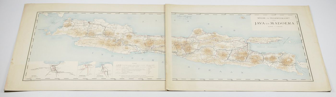
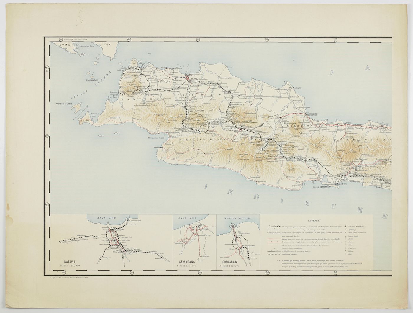
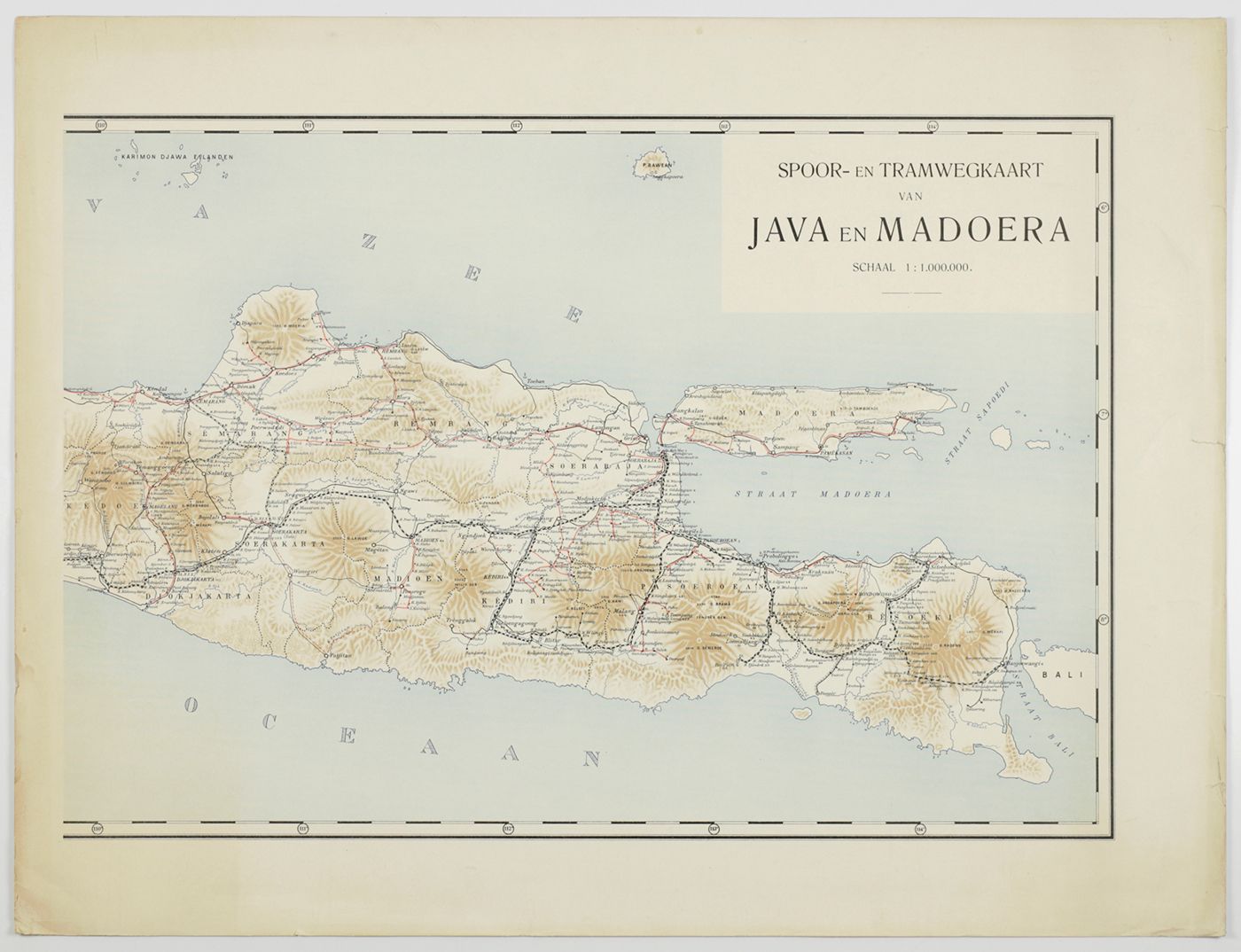
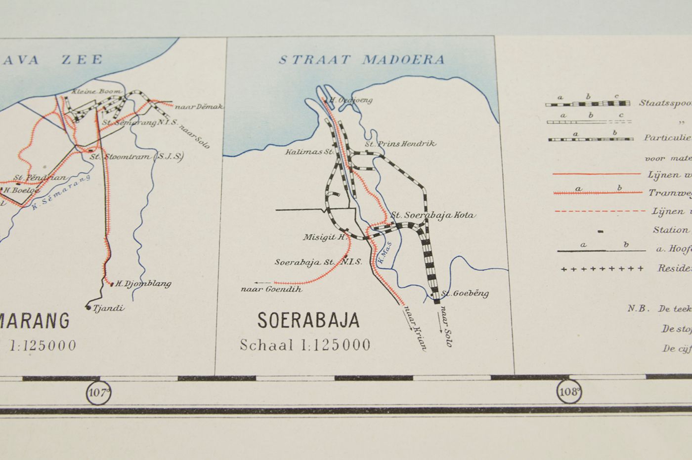
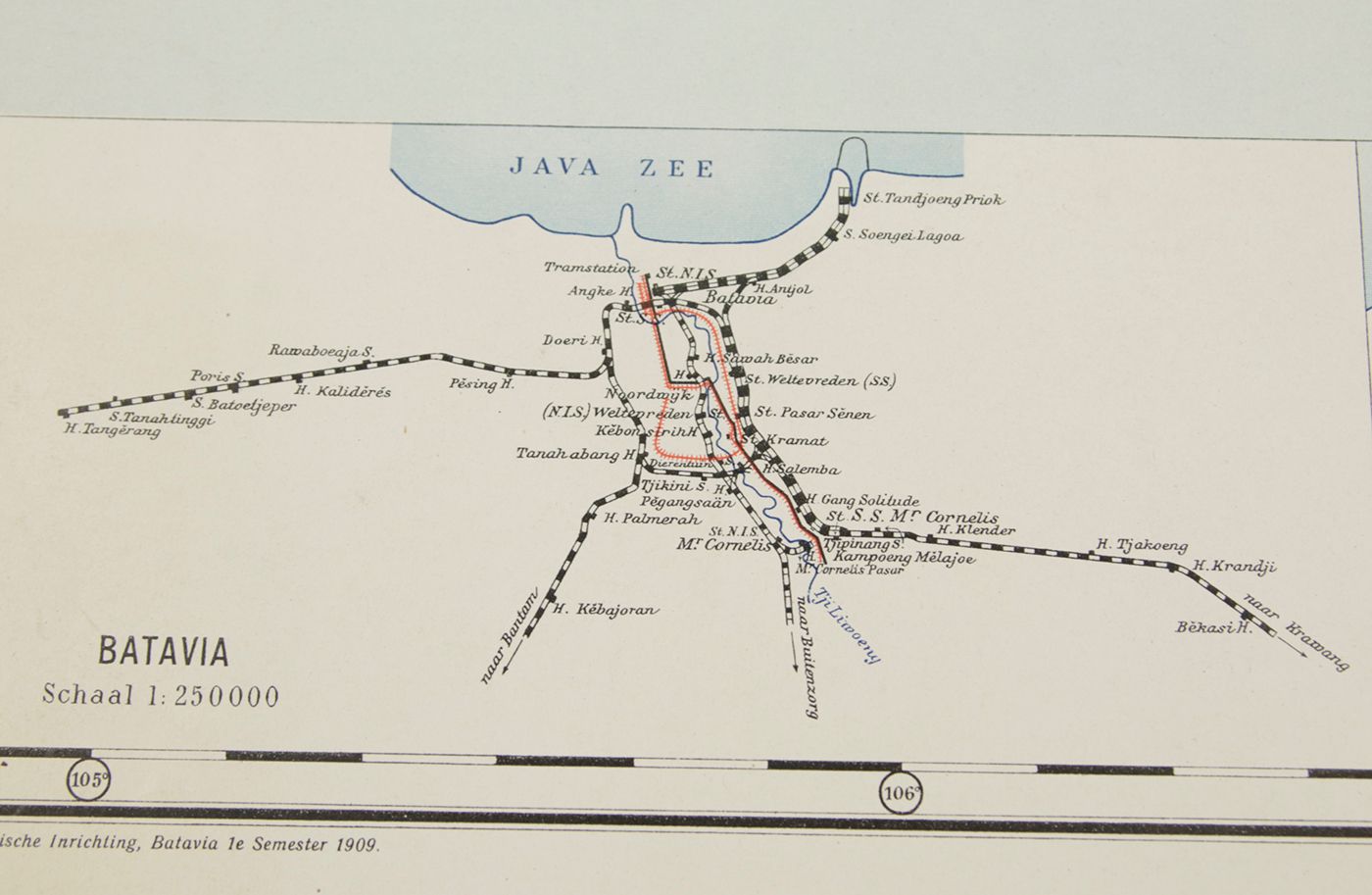
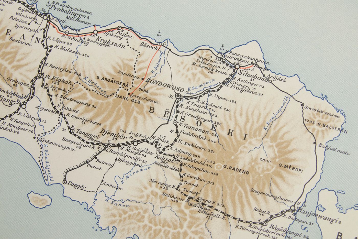
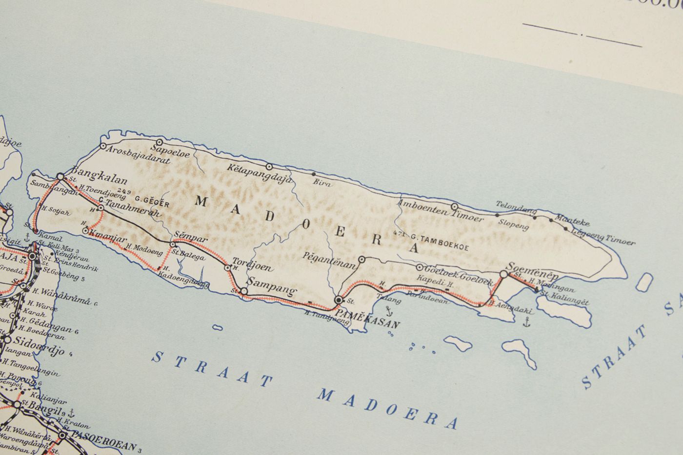
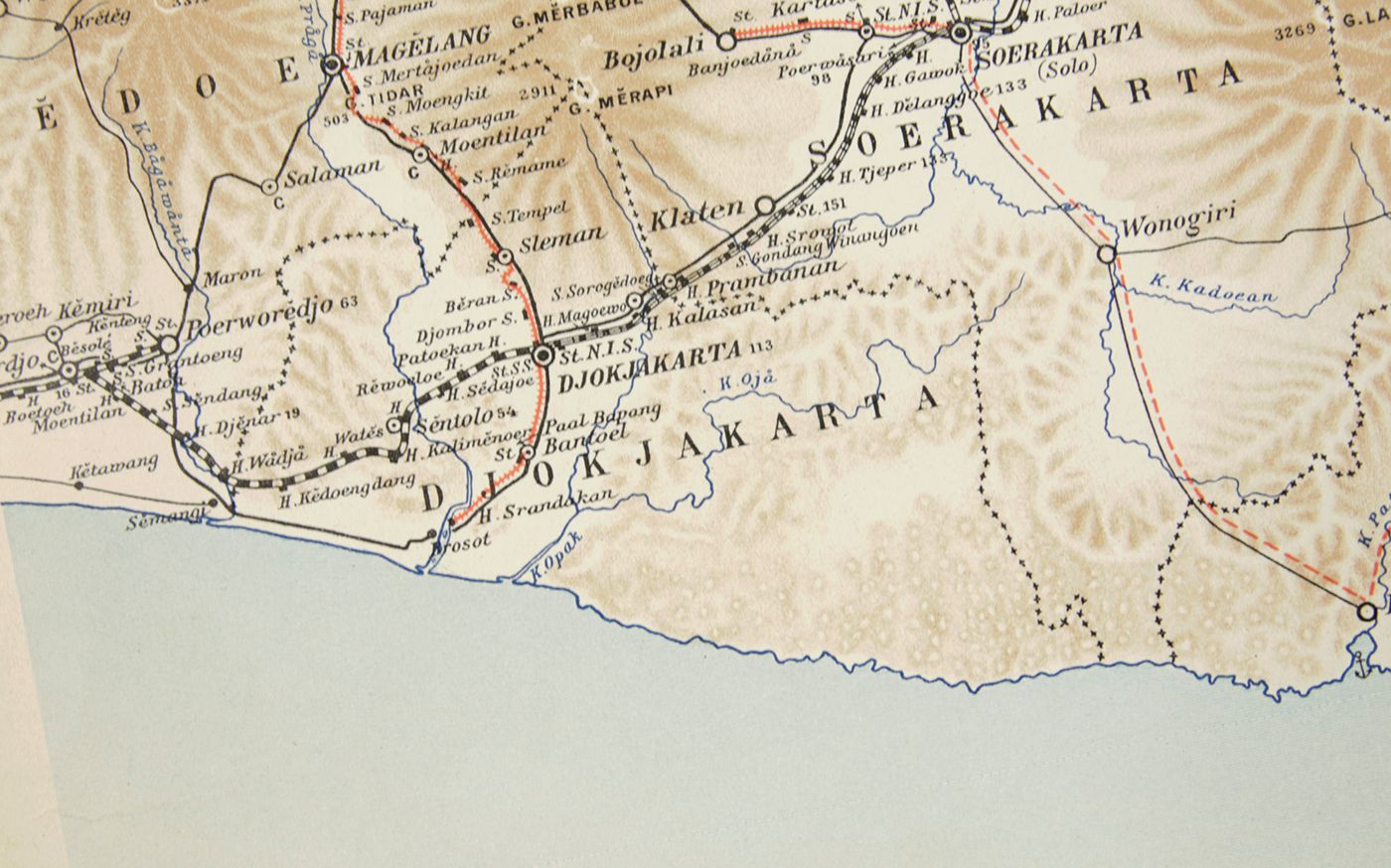
Spoor- en Tramwegkaart van Java en Madoera. [1909 edition].
Batavia, Topographische Inrichting, 1909. In two parts (both oblong, 49.0 x 64.5 cm). Colour printed. Versos blank.
The first rail and tramway maps of Java and Madura were published in 1898, on a scale of 1:1,000,000. In following years (1900, 1906, 1909, 1925 - the last on a reduced sheet) new, altered and updated editions were published. All are quite detailed, and include, e.g., towns, rivers, and provinces. In this 1909 edition, three smaller, more detailed maps (scale 1: 25,000) show the railway and tramway nets of the three largest towns on Java, Batavia (Jakarta), Semarang, and Soerabaja (Surabaja). Included are tracks in various stages of development (proposed, accepted, under construction, active). Outer margins very slightly frayed, and very lightly soiled, with a few tiny chips and tears, but generally very clean. a very good complete copy. Rare.

Recently Viewed
![image for Spoor- en Tramwegkaart van Java en Madoera. [1909 edition].](https://www.schierenberg.nl/media/cache/product_thumb/76139/76139_x.jpg)
![image for Vorstellung der Vögel Deutschlandes. Der grosse gepfeilte Falck. <em>Falco sagittatus</em>. Faucon. [plate 82]](https://www.schierenberg.nl/media/cache/product_thumb/73489/73489_x.jpg)
![image for [Wunderkammer - Giant Library] Durch Niederland, Teutschland, Hungarn, Serbien, Bulgarien, Macedonien, Thessalien, Oesterreich, Steirmarck, Kärnthen, Carniolen, Friaul, &c. gethane ganz sonderbare Reisen...](https://www.schierenberg.nl/media/cache/product_thumb/73078/73078_x.jpg)
![image for Les mollusques marins testacés du Maroc. Catalogue non critique. I. Les gastéropodes. II. Les lamellibranches et les scaphopodes. [AND] Premier supplement.](https://www.schierenberg.nl/media/cache/product_thumb/72079/72079.jpg)
![image for Traité d'anatomie générale ou histoire des tissus et de la composition chimique du corps humain. Volumes II-VIII, Atlas. [Complete].](https://www.schierenberg.nl/media/cache/product_thumb/67693/67693_x.jpg)
![image for Les récents voyages des Néerlandais à la Nouvelle-Guinée. [AND] Les derniers voyages des Néerlandais à la Nouvelle-Guinée.](https://www.schierenberg.nl/media/cache/product_thumb/31793/31793_x.jpg)
![image for La Guadeloupe dediée a Mgr. Charles Philippe d'Albert Duc de Luynes ... par son trés humble et trés obeissant serviteur Le Rouge, Ingr. géographe du Roy. [map of Guadeloupe and Bourbon (La Réunion)].](https://www.schierenberg.nl/media/cache/product_thumb/77206/77206_x.jpg)
![image for Physiotypia Plantarum Austriacarum. Der Naturselbstdruck in seiner Anwendung auf die Gefässpflanzen [Nature-printed plates 197-198]](https://www.schierenberg.nl/media/cache/product_thumb/69875/69875_x.jpg)
![image for Résultats des explorations zoologiques, botaniques, océanographiques et géologiques entreprises aux Indes Néerlandaises Orientale en 1899-1900, à bord du Siboga sous le commande de G. F. Tydeman, publiés par Max Weber. Livraison 1-148. [All published].](https://www.schierenberg.nl/media/cache/product_thumb/51581/51581_x.jpg)
![image for Vorstellungen allerhand Thiere. Plate XLIV [Seltene blaue Forelle]](https://www.schierenberg.nl/media/cache/product_thumb/69841/69841_x.jpg)
![image for Anatomie élémentaire. [Two fine anatomical plates]](https://www.schierenberg.nl/media/cache/product_thumb/69724/69724_x.jpg)
![image for The Oriental Sporting Magazine. From June, 1828, to June, 1833. In two volumes. [Complete].](https://www.schierenberg.nl/media/cache/product_thumb/34849/34849.jpg)
![image for Pfefferfresser. Tukane. [Tucans].](https://www.schierenberg.nl/media/cache/product_thumb/75775/75775_x.jpg)
![image for De Ambonse historie. Behelsende een kort verhaal der gedenkwaardigste geschiedenissen zo in vreede als oorlog voorgevallen sedert dat de Nederlandsche Oost Indische Comp: het besit in Amboina gehadt heeft [AND] De Ambonse historie. Behelsende een kort verhaal der Gedenkwaardigste Geschiedenissen zoo in vrede als oorlogh, voorgevallen zedert de regeering van den Superintendent Commissaris en Adml den wel Ed: Heer Arnold de Vlaming. En Eijndigende onder de Regeering van den Edele Agtb: Heer Jacob Hustard.](https://www.schierenberg.nl/media/cache/product_thumb/74106/74106.jpg)

![image for Plantae Hochreutineranae. Etude systématique et biologique des collections faites par l'auteur au cours de son voyage aux Indes Néerlandaises et autour du monde pendant les années 1903 à 1905. Fascicule I - VI. [Complete; with additional typed index].](https://www.schierenberg.nl/media/cache/product_thumb/20477/20477.jpg)
![image for Sea Sponge. [Plate XIX From: "Die Pflanzenthiere in Abbildungen nach der Natur mit Farben erleuchtet nebst Beschreibungen"].](https://www.schierenberg.nl/media/cache/product_thumb/69752/69752_x.jpg)
![image for Vorstellungen allerhand Thiere. Plate VIII [Delphin Karpf]](https://www.schierenberg.nl/media/cache/product_thumb/69840/69840_x.jpg)
![image for Blackheaded pheasant. Male [From: <em>Illustrations of Indian Zoology. Chiefly selected from the collection of Major-General Hardwicke. F.R.S.</em>].](https://www.schierenberg.nl/media/cache/product_thumb/77269/77269_x.jpg)
![image for Beschrijving van een nieuwen zoetwater-visch van Borneo, <em>Osteoglossum formosum</em>. [AND] Beschrijving van vier oost-Indische zeevisschen behoorende tot het geslacht <em>Amphacanthus</em>. [AND] Overzigt der uit de Sunda- en Moluksche zeeën bekende visschen van de geslachten <em>Amphiprion, Premnas, Pomacentrus, Clyphisodon, Dascyllus</em> en <em>Heliases</em>.](https://www.schierenberg.nl/media/cache/product_thumb/70391/70391_x.jpg)
![image for Physiotypia Plantarum Austriacarum. Der Naturselbstdruck in seiner Anwendung auf die Gefässpflanzen [Nature-printed plate 609]](https://www.schierenberg.nl/media/cache/product_thumb/69803/69803_x.jpg)
![image for Fauna Republicii Populare Romîne. Insecta volumul IX Fascicula 4. Familia Ichneumonidae. Subfamiliile Ichneumoninae. Tribui Ichneumoninae Stenopneusticae. [AND] Fascicula 5. Familia Ichneumonidae. Subfamiliile Phaeogeninae si Alomyinae.](https://www.schierenberg.nl/media/cache/product_thumb/74521/74521.jpg)
![image for De Bare'e sprekende Toradjas van Midden-Celebes. Tweede, geheel omgewerkte druk. [2nd, revised edition. Complete, in five volumes].](https://www.schierenberg.nl/media/cache/product_thumb/75785/75785_x.jpg)
![image for Collected fish papers of Pieter Bleeker. Collected and edited by W. H. Lamme. Volumes I-XIV. [Complete].](https://www.schierenberg.nl/media/cache/product_thumb/71215/71215_x.jpg)
![image for Over de zoogdieren van den Indischen Archipel. [On the mammals of the Malay Archipelago].](https://www.schierenberg.nl/media/cache/product_thumb/27651/27651.jpg)
![image for De Bare'e sprekende Toradjas van Midden-Celebes. [Complete, in four volumes].](https://www.schierenberg.nl/media/cache/product_thumb/15672/15672_x.jpg)
![image for Iconographie ichtyologique de l'Indochine: Poissons des campagnes du "de Lanessan" (1925-1929). 1re partie. [All published].](https://www.schierenberg.nl/media/cache/product_thumb/16588/16588_x.jpg)
![image for Some of Linné's reptiles and a mammal from Ceylon and elsewhere that are in Sweden. [AND] Some little-known characters of the two subspecies of <em> Lepidochelys olivacea</em> (Eschscholtz).](https://www.schierenberg.nl/media/cache/product_thumb/67083/67083_x.jpg)
![image for [Alert voyage] Report on the zoological collections made in the Indo-Pacific Ocean during the voyage of the HMS Alert 1881-1882.](https://www.schierenberg.nl/media/cache/product_thumb/75370/75370.jpg)
![image for Geographic and Oceanographic Research in Indian Waters. Part I - VIII. [All published].](https://www.schierenberg.nl/media/cache/product_thumb/76027/76027_x.jpg)
![image for Faust. Poligrafisch illustrirte Zeitschrift für Kunst, Wissenschaft, Industrie, und geselliges Leben, begleitet von Kunst-Beilagen aus mehr als 30 Druckfächern. [All photographic plates. Original prints, mounted, as issued].](https://www.schierenberg.nl/media/cache/product_thumb/71796/71796_x.jpg)
![image for Proceedings of the Symposium on Scombroid Fishes. Held at Mandapam Camp from Jan. 12-15, 1962. Part I - III. [Complete].](https://www.schierenberg.nl/media/cache/product_thumb/76055/76055.jpg)
![image for Histoire générale des voyages, ou nouvelle collection des toutes les relations de voyages par mer et par terre, qui ont été publiées jusq'à présent dans les différentes langues de toutes les nations connus: ... Tome dix-septième. Histoire générale des voyages, depuis le commencement du XVme siècle, dix-septième partie. Livre septième. Vies des gouverneurs généraux, avec l'abregé de l'histoire des etablissemens Hollandois aux Indes Orientales [AND] Histoire naturelle des Indes Orientales.](https://www.schierenberg.nl/media/cache/product_thumb/62296/62296.jpg)
![image for Farbige Räume und Bauten. [German Art Deco interior designs]. [AND] Farben für Mappe "Farbige Räume u. Bauten".](https://www.schierenberg.nl/media/cache/product_thumb/72403/72403_x.jpg)
![image for Expédition de la Célèbes Centrale. Voyages géologiques et géographiques à travers la Célèbes Centrale (1909-1910). Volumes I-III (text), atlas. [Complete].](https://www.schierenberg.nl/media/cache/product_thumb/38307/38307.jpg)
![image for Arbeiten aus der chirurgischen Klinik der Königlichen Universität Berlin. Erster Theil - Tritter Theil. [Complete].](https://www.schierenberg.nl/media/cache/product_thumb/66471/66471_x.jpg)
![image for Japanische Meeres-Conchylien. Ein Beitrag zur Kenntniss der Mollusken Japan's, mit besonderer Rücksicht auf die geographische Verbreitung derselben. I - III. [Complete].](https://www.schierenberg.nl/media/cache/product_thumb/75403/75403_x.jpg)
![image for <em>Eugenes spectabilis Lawr. [From: <em>A monograph of the Trochilidae or family of humming-birds</em>].</em>](https://www.schierenberg.nl/media/cache/product_thumb/74084/74084_x.jpg)
![image for Fauna et Anatomia Ceylanica. Zoologische Ergebnisse einer Ceylon-Reise ausgeführt mit Unterstützung der Ritter-Stiftung 1913/14. Band I-IV. [Complete].](https://www.schierenberg.nl/media/cache/product_thumb/75767/75767.jpg)
![image for The distribution of birds in Ceylon and its relation to recent geological changes in the island. [AND] Notes on Ceylon rails, waders, gulls, and terns. [AND] Notes on Ceylon water birds part II. [AND] Rough draft of Ceylon pigeons and game birds.](https://www.schierenberg.nl/media/cache/product_thumb/65538/65538.jpg)
![image for Vorstellungen allerhand Thiere. Plate LXIII [Adler]](https://www.schierenberg.nl/media/cache/product_thumb/69837/69837_x.jpg)
![image for [Portrait by Rudolf Fenzl]](https://www.schierenberg.nl/media/cache/product_thumb/69833/69833_x.jpg)

