[Various authors]
Annales des Mines. Series III-VI. Atlases.
Paris, Ecole de Mines, 1832-1866. Two series in four. Oblong folio (40.5 x 22.0 cm) with 758 (of 759? see below) engraved and lithographed plates and maps, of which 29 are hand-coloured geological maps or profiles. Contemporary uniform red cloth. Gilt titles on the spines and front boards. Marbled endpapers.
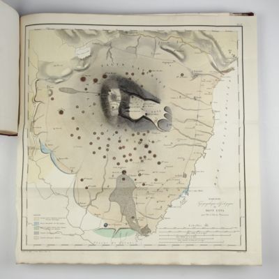
Rare atlas belonging to this early French mining journal that started as Journal des Mines(1794-1813) and was continued as Annales des Mines. It includes an early geological map of Los Angeles County (1855), a mining map of California (1862), maps of the volcanoes Mount Vesuvius and Etna, and a fine map of the island of Jersey (1851) with seven colours, etc., etc. Other plates show mining equipment, including locomotives, conveyor belts, and metallurgy devices, including ovens. One plate shows the reconstruction of an exploded boiler, with a map of the debris field, and views of damaged buildings, several others depict eruptions of Mount Vesuvius. In this set, nearly all the plates are not folded, in strong contrast to copies where the plates are included in the text volumes, nearly all folded, and often trimmed. Does not include plate VIII in serie III, volume XX [either not published or never bound in; it is described as Carte géologique de la Russie d'Europe, and should contain a "coupe géologique du nord au sud"; however, it is also lacking in the only other copy of série 3 vol. 20 that we have seen, and it is absent too in a digitalized copy on the internet (annales ensmp) The description of this plate in the "Explications des planches" is incomplete, as if the compiler had not seen it either]. All other plates present. Corners slightly worn, some very marginal water staining, but generally in very good condition. Cat. BM(NH) [Serial Publications] 1, 83.


![image for Description des Alpes, Pennines et Rhetiennes; dédiée a.s.m. très-chrétienne Louis XVI, roi de France et de Navarre. Tome premier - second. [Complete].](https://www.schierenberg.nl/media/cache/product_thumb/48650/48650.jpg)


