Earth Sciences - Geology
155 items found
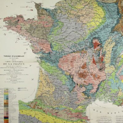
Belgrand, [M. F.] E.
Histoire générale de Paris. La Seine. I. Le bassin Parisien aux âges antéhistoriques.
Paris, Imprimerie Impériale, 1869. In three parts (Texte, Atlas de Paléontologie, and Planches de Géologie et de Conchyliologie). Large 4to and folio (33.8 x 23.9 cm). Texte: cvi, 289 pp., four double-sized coloured maps, 36 engraved text figures, five tissue-guarded plates (four profiles and one with stone age axes); Atlas: 82 [46, a-d] pp.; seven text engravings, 86 plates [1-79, 29bis, 48bis, 53bis, 59bis, 59ter, 62bis, 62ter, 78bis) being tissue guarded heliogravures of mammalian bones, including human skulls, etc., and stone age tools. Géologie and Conchyliologie, 32 pp. Three lithographed plates of shells, three very large folded, coloured geological profiles (numbered 5-7, being a suite to the maps in the text part). All in original green, printed boards or wrappers. Not in Nissen, ZBI.
Read more
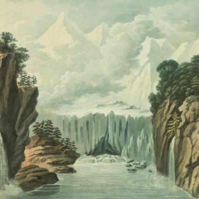
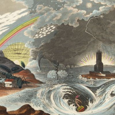
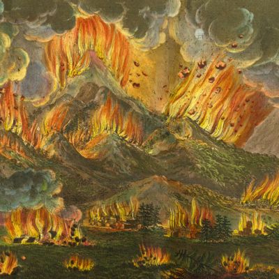
Belanger, L. and P. Vanlerberghe and S. Malgo
View of the torrent of the Lutschinen, and of the glaciers where it takes its source – Vue du torrent de la Lutschinen en Suisse, et des glaciers ou il prend sa source.
London, G. & W. Nicoll, 1800. Broadsheet (71.0 x 56.0 cm). Aquatint, finished by hand.
Read more
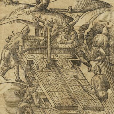
Beguin, J.
Les elemens de chymie de M. Iean Beguin aumosnier du roy. Reueuz, notez, expliquez, & augmentez, par I. L. D. R. B. IC. E. M. En cette derniere edition ont esté adiouttées plusieurs explications obmises aux precedentes impressions, & plusieurs preparations de remedes tirés de la derniere edition Latine.
Lyon, Claude Chancey, 1665. Small 8vo (15.6 x 9.5 cm). Title page with wood engraving, [xiv], 384, [xxiv] pp.; three wood-engravings in the text. Twentieth century full calf. Spine with five gilt-lined raised bands; compartments with small gilt floral vignettes and morocco label with gilt title. Marbled endpapers.
Read more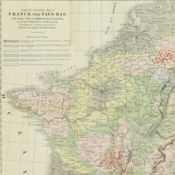
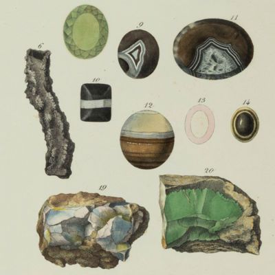
Beche, H. de la
A selection of the Geological Memoirs, contained in the Annales des Mines, together with a synoptical table of equivalent formations and Brongniart's table of the classification of mixed rocks. Translated with notes by H. T. de la Beche, Esq.
London, William Phillips, 1824. 8vo (21.1 x 13.3 cm). xxii, 335 pp.; one hand-coloured folded geological map of France and the Netherlands including a great part of Germany, the Alps and northern Italy, by J. d'Omalius d'Halloy (numbered plate 11 [not II]) and two further hand-coloured geological maps or profiles (numbered I-II), eight folded lithographed plates (numbered III-X), including a very fine view of the coalmine at Treuil near St. Etienne, one folding table. Contemporary half calf over marbled boards. Spine with gilt lines and title. Edges speckled red.
Read more
Barrande, J.
Systême Silurien du Centre de la Bohême. Première partie: Recherches paléontologiques. Continuation éditée par le Musée Bohême. Vol. II. Classe des mollusques, ordre des céphalopodes. Texte et 544 planches.
Prague, Musée Bohême, 1867-1877. 11 parts in 11. Large 4to and folio (32.5 x 25.5). 3,583 pp.; 545 lithographed plates (including 240bis) with explanatory text leaves. Original near uniform blind-tooled cloth with gilt title on the spines.
Read more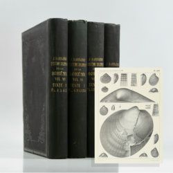
Barrande, J.
Systême Silurien du Centre de la Bohême. Première partie: Recherches paléontologiques. Continuation éditée par le Musée Bohême. Vol. VI. Classe des mollusques, ordre des acéphales. Texte et 361 planches. [Bivalvia].
Prague, Musée Bohême, 1881. Four parts in four. Large 4to (32.8 x 26.0 cm). xxiv, 342 pp.; 361 lithographed plates with explanatory text leaves. Original uniform blind-tooled black cloth with gilt title on the spines.
Read more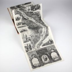
Arnold, F.
Halenza's neuestes Rhein-Panorama von Mainz bis Cöln. Einziges, durch die Berliner und Frankfurter Künstler gefässtes Urtheil, anerkanntes Kustwerk. Panorama du Rhin depuis Mayence jusq'à Cologne. Panorama of the Rhine, from Mentz to Cologne. [Complete with the rare text volume].
Mainz, J. Halenza, [1880]. Two parts in two. 8vo (text: 26.4 x 16.2 cm). Title page, 24 pp. (in English). Panorama: One folding lithographed view by F. Foltz (27 x 230 cm). Contained in original printed boards with the German title on one board, and the French/English titles on the other.
Read more
Allemann, F.
Geologische Karte Fürstentum Liechtenstein.
[Vaduz], Regierung des Fürstentums Liechtenstein, 1953. Large (102.0 x 67.0 cm), folded map, consisting of 25 rectangular sheets in full colour, mounted on linen. Handwritten and stamped label on the front-facing part of the linen map verso.
Read more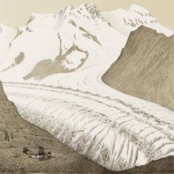
Agassiz, L.
Untersuchungen über die Gletscher. [Complete text and atlas].
Solothurn, Jent & Gassmann, 1840-1841; Neuchatel, H. Nicolet, 1840. Text: 8vo (21.5 x 14.2 cm). xii, 326, [i] pp. 19th-century pebbled half cloth over marbled boards. Spine with gilt ornamental bands and title. Greenish endpapers. Subtly marbled edges. Atlas: Oblong folio (29.7 x 44.0 cm). 18 lithographed plates of which 14 with printed overlays (as intended). Contemporary green quarter calf over green boards. Spine with gilt bands. Original pictorial title mounted on front board.
Read more
Adriani, N. and A. C. Kruyt
De Bare'e sprekende Toradjas van Midden-Celebes. [Complete, in four volumes].
Batavia, Landsdrukkerij, 1912-1914. In four volumes. Text in three octavo volumes (26.5 x 18.0 cm) [AND] atlas in folio portfolio (37.0 x 26.5 cm). 1,636 pp.; 58 photographs on 26 sheets, 13 coloured plates of which seven partly in full colour, and four coloured folding maps (two showing adjacent regions). Original uniform quarter cloth over printed boards.
Read more
